
WINTER 2004
Belmont Bay: Community Critique
A simple, sensible neighborhood evaluation system can
be useful in several ways. It can recognize the accomplishments of talented
designers, planners and developers. It can be a teaching tool, illustrating
the ways hybrid developments can be improved. And it's a way to communicate
good urban design principles: It supplements guidebooks, case studies
and checklists, and provides a more objective definition of new urbanism.
There are numerous evaluations systems in use or under development. Criterion
Planners/Engineers have developed one of the most objective systems that
relies on the number-crunching power of GIS. The system known as LEED-ND
may turn out to be the most comprehensive and authoritative. Still, there's
a need for a simple system that non-experts, with no specialized tools,
can use with commonly available information. Invariably, a simplified
system will miss things that some people consider critical. The advantage
is greater participation and awareness of the quality of the built environment.
This article applies a simplified evaluation system to the community of
Belmont Bay, in Woodbridge, Va. The site is 14 miles south of Washington
D.C. in suburban Prince William county, gloriously situated on the banks
of the Occoquan River. It is sandwiched between the major I-95/Route 1
transportation corridor and the Occoquan Bay National Wildlife Refuge.
To the east and south there are fine views of the river and the marshlands.
Belmont Bay is a complex project to evaluate. Its 325 acres have several
discontinuous areas of development, each built at different times, under
different ownership structures, and with different zoning codes. As I
toured the community, I was by turns disappointed and pleasantly surprised.
Belmont Bay's town center is the only section developed with a new urbanist
zoning code, while the other parcels were or are currently being developed
as various forms of conventional suburban development. Therefore, this
evaluation focuses on the 80-acre town center.
Planning for the town center took place in 1998-99. Prince William County
encouraged modifications of the existing zoning code to create a mixed-use,
pedestrian-oriented town center. Groundbreaking took place in 2000 and
the development has been extremely successful, boasting strong appreciation
in home prices over the past four years. Belmont Bay's first condominium
was the county's largest, superseded only by the nine-story condominium
now under construction one block away. Underlying all this activity is
the county's sizzling growth in jobs -- last year it had the fastest employment
growth rate in the nation.
About the ratings: All ratings are on a scale of 1 to 5 stars. In general,
5 stars is equivalent to a well-designed, early twentieth-century, urban
neighborhood in the United States. All ratings are based on existing construction
and future plans as of October, 2004.
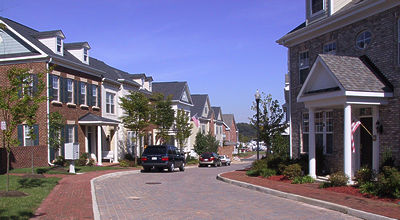 A one-way, one-travel-lane side street. Photo: Laurence Aurbach |
Existing residential types are about 55 percent condos of various sizes
and 45 percent townhouses, with a few detached dwellings. The southern
portion of the town center may be developed as condo towers, which would
decrease the score. On the other hand, counting the townhouses and detached
dwellings in the land parcels near the town center would increase the
score.
There are public and private recreational facilities, a specialty shop
and a school within walking distance, while planned uses are office, specialty
retail and restaurants, regional science museum, church, and hotel. Developer
Preston Caruthers donated land for the school, commuter rail station and
future museum.
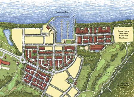 An early version of the site plan. The residential areas are built as illustrated. The areas in yellow (mixed-use and age-restricted components) will use a different plan. Image courtesy of EFO Management. |
This is a measure of how direct are the travel routes within the development,
and how many options there are for traveling between any two points. A
rough measure used by several municipalities is the connectivity index,
defined as the ratio of street segments (links) to intersections and dead-ends
(nodes). The connectivity index gives a rough idea of how many 3 and 4-way
intersections are in the development. In Belmont Bay, there are 111 links
and 77 nodes for a ratio of 1.44, or three stars. However, 10 percent
of the nodes are short alleyway dead-ends with connecting pedestrian passages.
The pedestrian network has 155 links and 97 nodes, with an index of 1.60
equaling five stars. The average of both indexes is 1.52.
The town center has a 10,600 foot perimeter, but the property is surrounded
by water, a National Wildlife Refuge, and wetlands. Only 2,700 feet of
the perimeter are adjacent to developed or developable land. There are
two ingress/egress points, with an average of 1,350 feet between ingress/egress
points. Most greenfield TNDs score poorly on this.
This is measured by the percentage of dwellings within walking distance,
sometimes called "ped shed." Ped shed of school: 100 percent of dwellings
will be within 1 mile of a school -- 5 stars. Ped shed of town center:
90-100 percent of dwellings will be within 1/4-mile of town center --
five stars. Ped shed of parks: 90-plus percent of dwellings will be within
1/8-mile of a park or green -- five stars. Ped shed of transit: No dwellings
will be within 1/2 mile of a transit stop -- one star. However, consider
the bike shed for transit: All dwellings will be within 2 miles of a major
commuter rail station with bicycle racks -- five stars.
Average block length measured along the longest axis is 370 feet.
The following five elements (streetscape, frontages, architecture, civic
space, location) involve more subjective judgement.
There are good street widths on the side streets. As an example, one-way,
one lane streets with parking on one side have a remarkable width of 18
feet. The main thoroughfares are somewhat oversized. An example is a 36-foot
width for a two way, two lane street with parking on both sides. Curb
radii are short throughout, which helps calm traffic and makes crossing
the streets easier. Sidewalks average 4 feet in width. Good attention
is paid to paving materials and street furniture. Traffic circles are
properly sized and configured. Utility, phone and mail boxes are often
intrusively placed.
Variable design quality. There are some very tight frontages; the best
of these create the high level of civic comfort that exists in traditional
Virginian towns. Substantial street walls reinforce lot lines in some
locations. Many porches and balconies are too narrow at 4-5 foot depth.
Some ground floors should be a few feet higher above the sidewalk. Some
landscaping is a bit suburban for the intensity of land use.
Ranges from an a-contextual, middling quality to fairly good in some cases.
Developer Jim Epstein worked with production builders to improve the details,
such as brick siding instead of HardiPlank on prominent facades; the results
vary. Sometimes the proportions, massing, and siting are managed well,
while certain other instances are disappointing or clumsy. Alleyways tend
toward the mechanical repetition common in many TNDs. The range is 2 to
4 stars with an average of three.
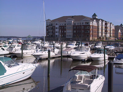 A private marina in the heart of Belmont Bay's town center. Photo: Laurence Aurbach |
Excellent waterfront promenade at marina. In three spots, greens at mid-block
interrupt the alleyways, providing visual variety and views of landscaping.
Several other mid-block passageways provide extra pedestrian paths. Some
awkward configurations and intruding utility fixtures. Caruthers has discussed
the possibility of placing a church steeple to terminate the vistas from
the main entrance and from the waterfront park; if executed, this element
will be a fine enhancement.
On the shore of the Occoquan River, with no or minimal buffer. That's
a bad thing from an environmental point of view, but from an urbanist's
point of view, the rustic scenery is the main reason the high density
condo buildings have sold so well. The removal of the natural shore buffer
vegetation must be balanced against Belmont Bay's environmental advantages:
less land consumption and paved surfaces per person. The site is in a
suburban area, near a major transportation corridor; driving is required
for most daily tasks. At the time of purchase the site was zoned industrial
and was sandwiched between rail tracks and a Army weapons research complex.
Environmental and financial performance are extremely important, but at
this point I can only offer comments, not ratings.
Of Belmont Bay's 325 acres, 60 percent are developed and 40 percent are
open space (golf course and wetlands). The town center is part of Belmont
Bay's stormwater district that directs most runoff to the surrounding
golf course, ponds and wetlands. In the town center, runoff goes to small
catchment basins before being discharged into the river. The marina promotes
non-polluting boating practices.
The condominiums along the shore were the fastest-selling projects in
the Washington, D.C. region for 2002. Condominium prices have appreciated
more than 60 percent over the past two and a half years.
There are many other important factors that could be evaluated, given
enough resources for research and reliable standards for evaluation, like
construction quality, affordability and governance. More importantly,
the weighting of individual factors is something few people can agree
on. This rating system is without question incomplete, and should be continually
refined, developed and tested.
In summary, Belmont Bay successfully creates a sense of place and a reasonably
attractive, walkable environment for its residents. Its current character
is that of a resort, retreat and low-maintenance bedroom community for
young professionals and retirees. The execution of design is uneven, although
certain elements are quite well done. Belmont Bay's ultimate quality as
a town center destination will depend on whether future phases are seamlessly
connected to existing phases, whether they match the existing character
of the town center, and whether they employ the techniques of full pedestrian
orientation.
Note: A complete guidebook to using the TND Design Rating System is
available for download here.
Belmont Bay Statistics
Name: Belmont Bay Town Center
Location: Woodbridge, Va.
Designers: Torti Gallas and Partners (existing components), Belmont Development
Associates (future commercial and age-restricted components)
Developers: EFO Capital Management, Belmont Development Associates
Area: Total Belmont Bay property: 352 acres. Town center: 80 acres
Number of dwellings built or under construction: 452
Total dwellings permitted: 1350